


Water Monitoring / Groundwater

Groundwater Monitoring Services in Western Australia

Groundwater is a critical resource in arid climates with low rainfall, and in Western Australia it underpins everything from remote community water supply to large-scale mining operations. Understanding what is happening beneath the surface requires structured and ongoing measurement to ensure the quality, levels and consumption are fit for purpose along with being socially and environmentally aware.
Enquire now

Enquire About Groundwater Monitoring

what it is

Groundwater monitoring: what it is and why it matters for your site

Groundwater monitoring is the systematic measurement of groundwater levels and groundwater quality over time. It provides the data needed to understand aquifer behaviour, quantify drawdown from extraction or dewatering, track recharge after rainfall, and identify potential contamination before it becomes a serious problem. For mining, construction and industrial projects across Western Australia, this data is not optional – it is a regulatory requirement and a practical necessity.

Groundwater accounts for 30% of water consumption in Australia and provides drinking water for up to 50% of the population. In WA specifically, water security in Perth relies on sustainable management of groundwater resources, making accurate and reliable data from monitoring programs essential for protecting these supplies. Groundwater monitoring measures physical, chemical, and biological parameters to assess aquifer status and trends over time, giving operators the information they need to make informed decisions about water use and environmental management.

Environmental Site Services (ENVSS) designs and delivers practical field programs that help clients demonstrate regulatory compliance and protect groundwater resources. As part of a broader water monitoring capability, ENVSS provides experienced technicians, modern equipment and accurate data collection across the full project lifecycle. Groundwater monitoring also works alongside surface water monitoring to understand connections between aquifer systems, rivers, wetlands and drainage – particularly where dewatering or land disturbance may affect surface flows.

Groundwater levels and quality must be monitored due to declining rainfall affecting aquifers across much of WA, particularly in the southwest. Without reliable data, sites risk breaching environmental approvals, harming ecosystems, or permanently degrading water resources through over-extraction, saline intrusion or undetected contamination.

how its used

How groundwater is used in Western Australia

Western Australia depends on groundwater across multiple sectors.
Understanding these uses explains why monitoring is so important and why the consequences of poor data can be severe.

Environmental values. Groundwater supports local ecosystems and biodiversity across the state. Groundwater-dependent ecosystems such as wetlands, springs and riparian vegetation rely on stable water table levels. Research in East Gnangara found that particular Banksia species suffer stress when depth to water exceeds approximately 6 metres, with tolerable drawdown limited to around 1.5 metres total and no more than 0.2 metres per year.

Mining operations. Groundwater plays a central role in mining activities – from dewatering pits to allow below-water-table extraction, to supplying process water for mineral processing and dust suppression. Level monitoring helps manage these operations and ensures abstraction stays within approved limits. In the Pilbara, some operations abstract roughly 47 ML/day, with surplus water either reinjected or used beneficially.

Drinking water supply. Perth relies heavily on groundwater for drinking, industry, and agriculture. Many regional and remote communities across WA use groundwater as their primary potable water source, and it becomes an even more important source during dry years when surface water supplies are depleted.

Agriculture and irrigation. Groundwater is essential for irrigation and agriculture in key horticultural districts across the Perth Basin, around the Gnangara Mound, and in other productive regions. Farmers depend on suitable salinity levels and adequate quantity to sustain crops, orchards and grazing operations.

Urban and public amenities. Monitoring helps to manage urban green spaces by ensuring healthy groundwater levels that support parks, reserves and urban vegetation in Perth and other centres.

Groundwater monitoring assists in preventing pollution and managing climate impact risks across all of these uses. Without credible monitoring data, it is not possible to assess whether extraction remains sustainable or whether groundwater conditions are changing in ways that threaten ecosystems, industries or communities.
level monitoring

Groundwater level monitoring techniques

Most sites use a combination of manual and automated methods to monitor groundwater levels. Manual measurements provide point-in-time records during scheduled visits, while automatic loggers capture continuous datasets that reveal short-term fluctuations and longer-term trends.

Tracking groundwater level changes over time is fundamental for understanding drawdown from pumping, natural recharge patterns, and potential impacts on neighbouring bores, springs and ecosystems. Groundwater monitoring helps assess aquifer status and trends over time, enabling effective monitoring and management of the resource.

ENVSS field technicians select level monitoring methods based on site access, safety considerations, environmental regulations, and the frequency of data needed. The following subsections describe each approach in detail.

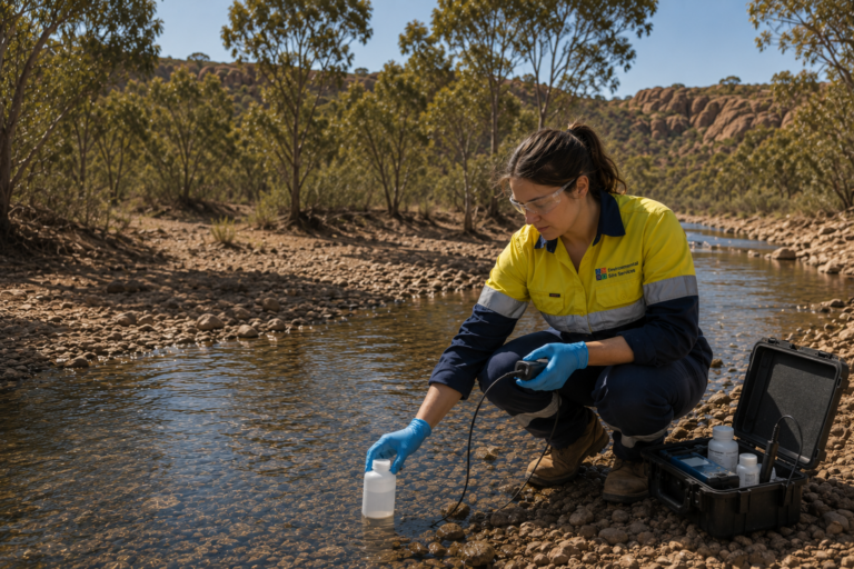
female worker at envss collecting water sample from creek

Manual groundwater level monitoring

Manual monitoring uses a dipper to measure groundwater levels – typically an electric water level indicator lowered into the bore until it contacts the water surface. The depth to water is read from a graduated cable or tape, measured relative to a surveyed reference point at the top of the well casing.

A typical manual monitoring event involves:

  • Checking wellhead condition, security and access

  • Lowering the dipper or tape into the monitoring bore

  • Recording standing water level relative to the surveyed datum

  • Noting well conditions such as turbidity, odour or debris

  • Recording date, time, barometric pressure and water temperature

  • Documenting results using consistent field sheets and procedures

Manual measurements are typically collected during scheduled monitoring events – monthly, quarterly, or as required by licence conditions. This approach is suitable for baseline investigations, low-risk sites and remote locations where automatic systems may not be justified.

The main limitation is frequency. Monthly or quarterly visits will miss short-term fluctuations caused by pumping cycles, rainfall events or tidal influences. Manual methods are also labour-intensive and dependent on safe site access. ENVSS technicians apply consistent field procedures, calibration checks and documentation standards so that manual groundwater level data remains defensible for regulatory reporting.

Automatic groundwater level monitoring

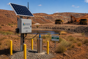
Automatic groundwater monitoring systems transmit data remotely or store it locally, providing continuous level records that capture changes not visible in manual datasets. Pressure transducer data loggers are installed in monitoring wells at specific depths, programmed to record water level and temperature at set intervals – often hourly or sub-hourly.

Data can be retrieved manually during site visits or transmitted via telemetry (cellular, satellite or radio) to secure databases in near real time. Barometric compensation sensors are typically included so readings can be corrected for atmospheric pressure changes, which is critical for accurate groundwater level data.

Key advantages of automatic level monitoring include:

  • High-resolution datasets that separate rainfall, pumping and seasonal effects

  • Early detection of abnormal drawdown, recovery trends or aquifer stress

  • Reduced reliance on site visits for data collection

  • Ability to measure pore water pressure in specific geological units

Vibrating wire piezometers measure pore water pressure accurately in geotechnical and hydrogeological applications, and are commonly installed in embankments, tailings facilities and around underground workings where water pressure data is critical.

Technologies like InSAR can also measure ground deformations caused by groundwater extraction, providing a complementary dataset for understanding regional aquifer responses.

ENVSS integrates logger data with manual measurements and rainfall records to develop clear hydrographs and trend analyses. This combined approach gives clients reliable data on both broad seasonal patterns and short-term aquifer responses.

Groundwater quality sampling and analysis

Groundwater quality monitoring complements level monitoring to give a complete picture of aquifer condition. While levels tell you how much water is present, quality data tells you whether that water is safe, uncontaminated and suitable for its intended use.

Typical drivers for quality monitoring in WA include:

  • Compliance with Department of Water and Environmental Regulation (DWER) licence conditions

  • Part V operating licences under the Environmental Protection Act 1986

  • Contaminated sites investigations under the Contaminated Sites Act 2003

  • Mine closure studies and Groundwater Operating Strategies

  • Environmental impact assessments and baseline investigations

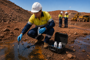
The standard field process involves purging monitoring wells until representative formation water is being drawn, then measuring field parameters including pH, electrical conductivity, temperature, dissolved oxygen, redox potential and turbidity. Once parameters stabilise, water samples are collected using clean sampling techniques, appropriate bottles and preservatives, with full chain-of-custody documentation.

Groundwater quality is assessed using over 40 parameters in many programs. Common analytes in WA include:

Parameter GroupExamples
💧 Salinity IndicatorsTotal dissolved solids (TDS), Electrical conductivity (EC)
🧪 Major IonsSodium, Potassium, Calcium, Magnesium, Chloride, Sulfate
🌱 NutrientsNitrate, Ammonium, Phosphorus
⚙️ MetalsIron, Manganese, Arsenic, Mercury, Zinc
🛢️ Organic CompoundsHydrocarbons, Solvents, PFAS
🧬 OtherPesticides, Chemical Oxygen Demand (COD)

Monitoring identifies potential contamination from heavy metals, pesticides, or saltwater intrusion – all of which can affect groundwater resources if left undetected. Groundwater monitoring can detect contamination from pesticides and heavy metals at concentrations well below levels that would cause visible harm, providing early warning for management action.

ENVSS applies strict quality assurance and quality control processes: duplicate samples, field blanks, equipment rinse blanks and chain-of-custody records. All laboratory analysis is performed by NATA-accredited laboratories, and results are presented against relevant guidelines and site-specific criteria in clear, practical reports.

Monitoring wells

Monitoring wells: design, construction and maintenance

Monitoring wells – also called groundwater monitoring bores – are the core infrastructure for accessing groundwater levels and groundwater quality data. Groundwater monitoring involves drilling boreholes for water sampling and level measurement, with well design tailored to the target aquifer, geology and monitoring objectives.

Key design considerations include:

  • Casing and screen materialsPVC or stainless steel, selected based on chemical compatibility and depth

  • Screen intervals – positioned at specific depths to isolate the target aquifer zone

  • Filter packs and seals – gravel filter packs around screens, with bentonite or cement seals to prevent cross-contamination between strata

  • Well development – purging and surging after construction to remove fine sediments and establish reliable hydraulic connection

Spacing and layout of bore holes depends on the project. Wells are typically placed upgradient and downgradient of potential contamination sources – around mine pits, tailings facilities, landfills, industrial areas and infrastructure corridors. Background reference wells in unaffected areas are essential for comparison.

For context, Bravus Mining has over 120 monitoring bores around the Carmichael Mine, demonstrating the scale of monitoring networks required for major resource projects.

Long term monitoring programs rely on ongoing well maintenance – regular condition inspections, cleaning, checking seals and caps, and periodic rehabilitation to maintain data quality over years or decades. ENVSS works with drilling contractors and project engineers to plan monitoring well networks that satisfy environmental approvals and investigation objectives.

Designing

Designing a groundwater monitoring program

Program design is a risk-based process that starts with understanding the project stage, hydrogeological setting and regulatory conditions. ENVSS approaches this practically: what are the groundwater receptors at risk, what does the regulator require, and what data will answer the key questions?

Key inputs to program design include:

  • Project stage – baseline, construction, operations or closure each demand different monitoring intensity

  • Hydrogeological setting – aquifer type, depth, recharge rates, transmissivity, natural groundwater conditions

  • Regulatory conditions – licence requirements, Ministerial Statement conditions, Groundwater Operating Strategies

  • Receptors – nearby bores, wetlands, springs, groundwater-dependent ecosystems

These inputs are translated into decisions about bore locations, screen depths, analyte suites, level monitoring methods and sampling frequency. Establishing baseline groundwater conditions before disturbance is crucial – ideally over at least one full hydrological year – so that later data can be compared to understand whether changes are occurring and whether they are within acceptable limits.

The Perth Regional Aquifer Modelling System simulates aquifer responses to environmental changes, and tools like this inform regional-scale monitoring design. At the site level, programs often integrate both groundwater and surface water monitoring to capture connections between aquifer recharge, rainfall, runoff and ecological receptors.

Effective monitoring enables informed decision-making for sustainable water resource management. Clear data management – consistent bore naming, metadata, field templates and version control – supports long-term trend analysis and makes reporting straightforward.

context and reporting

Regulatory context and reporting in Western Australia

Groundwater monitoring programs require compliance with environmental regulations and licensing conditions across several WA legislative frameworks.

Groundwater monitoring programs require compliance with environmental regulations and licensing conditions across several WA legislative frameworks. Most projects will engage with one or more of the following:

  • Environmental Protection Act 1986 (WA) – Part IV approvals, Ministerial Statements, Part V operating licences

  • Rights in Water and Irrigation Act 1914 – water abstraction licences, well construction permits, Groundwater Operating Strategies

  • Contaminated Sites Act 2003 (WA) – investigation and remediation of affected groundwater

  • Mining Act 1978 (WA) – conditions attached to mining proposals and approvals

Groundwater monitoring data supports ensuring compliance with DWER licence conditions, Ministerial Statements and site-specific management plans. Regular monitoring helps ensure groundwater extraction remains sustainable and compliant, and provides the evidence base for annual environmental reports, compliance assessments and mine closure planning.

ENVSS prepares a range of reports including baseline groundwater assessments, periodic compliance monitoring reports, annual environmental reports and mine closure groundwater summaries. Each report presents groundwater levels, groundwater quality results and trend interpretations in clear figures and tables that can be used directly in broader approvals and environmental management plans.

Defensible environmental data and clear documentation are essential when engaging with regulators, stakeholders and auditors. Groundwater monitoring is essential for informed groundwater management decisions – and the data provided must withstand scrutiny.

Site Services

How Environmental Site Services delivers reliable groundwater monitoring

ENVSS is a field-focused environmental consultancy with experienced groundwater technicians operating across Western Australia, from the Perth metropolitan area to remote mining regions. The team understands the realities of working on active mine sites, construction projects and operating facilities in challenging environments.

Key strengths include:

  • Fast mobilisation throughout WA, including remote and regional areas

  • Modern monitoring equipment – electric dippers, pressure transducer loggers, vibrating wire piezometer systems, multiparameter sondes and sensors

  • Consistent sampling methodologies and robust QA/QC processes

  • Experience across mining, infrastructure, industrial, contaminated land and government projects

  • Support through the full project lifecycle – from baseline investigations through to operational compliance and closure

ENVSS works closely with environmental managers, consultants and project teams to integrate critical data from groundwater monitoring into broader environmental performance and risk management frameworks. The focus is always on collecting reliable, defensible data that clients can use with confidence.

If your project requires groundwater monitoring – whether for baseline studies, operational compliance, contaminated site investigations or long-term environmental reporting – contact Environmental Site Services to discuss your monitoring requirements or request a monitoring proposal.

Solar Powered

Deep cycle batteries and solar panels to keep equipment operating autonomosuly​

5G Connectivity​

GPRS modem to keep you connected

Automated Reporting​

Customisable automated reports to save you time and focus on what's important

Alerts

Customisable SMS, email, audible and visual alerts

Data Storage

Cloud based servers to securely store your data

WHY CHOOSE US?